Find the best routes for riding your electric scooter using these navigation and ride tracking apps, which are all Android and iOS compatible. We’ve ranked these mobile apps based on features including price, availability across regions, audio navigation, and offline maps.
Best Navigation Apps for Electric Scooter Riders

Google Maps | Best All-Around Navigation App
Google Maps app | iOS + Android | Free | Cycling mode
Google Maps is the best navigation app for scooter riding because it provides multiple routes for each trip, offers various routes by mode of transportation (walk, car, bike, public transportation, and ride shares), and can navigate routes anywhere in the world — all for free.
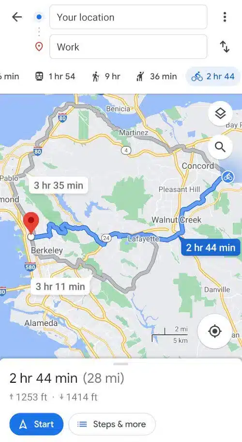
The Google Maps UI is very user-friendly and easy to navigate, and offers the same features for both mobile and web interfaces. You can save routes you frequent, share routes with others, and view the map with terrain, traffic, and transit details. Audio navigation is especially important when riding a scooter, as you can listen to directions while keeping your eyes on the road.
Google Maps includes turn-by-turn audio instructions as well as offline maps, which allows you to reach your destination even if you lose signal throughout the trip. The Commute feature allows you to plan the best times to travel based on current commuting statistics for your destination. Using bicycle mode, Google Maps (compared to CityMapper and ScootRoute) found routes with the best road conditions using bike lanes, including some bike paths we did not know about, where visibility around corners was strong.
Although you cannot record rides or associate media (like photos or videos) with rides, Google Maps is still the best navigation app for scooter riders given its robust, free features.
CityMapper | Best Multi-Mode Navigation App
CityMapper | iOS + Android | $3.99/month | Cycling mode
CityMapper is the best navigation app if you plan to utilize more than one mode of transportation — like if you walk to the subway, take it into the city, and then find a shared scooter near the station to get to your destination.

CityMapper is the only navigation app that we’ve reviewed that provides various routes using different modes of transportation. We use Bicycle mode for scooter riding, but note that audio navigation for riding a bike is only available with subscription ($3.99/month, $29.99/year for Club, $99.99/year for Club+). If you use Walk mode, audio navigation is included.
Keep in mind that you cannot use CityMapper for navigating in a car, as the transportation modes include walking, cycling, or using a shared service like Uber or public transportation. You can save frequent routes and share routes with others, plan routes on the web and send to your phone for free, but downloading maps requires a subscription.
CityMapper does not have a terrain or elevation view, and like Google Maps does not have a feature for associating photos and videos with trips. CityMapper has a clean but complex UI, is available in select regions (mostly large cities in the United States and United Kingdom), and provides multiple routes per bicycle trip. Labeled as Quiet, Regular and Fast, these route styles result in slightly different directions and trip times.
When we used the Quiet route, we reached our destination slightly faster than the Regular route but it took us through residential areas (no bike lanes) with some poor road conditions and limited visibility around corners. CityMapper is an excellent choice if you’re a multi-mode traveler living in a region that the app supports.
Komoot | Best Outdoor Exploration App
Komoot | iOS + Android | $4.99/month | Hiking + Cycling modes
Komoot is an excellent navigation and activity tracking app if you’re in search of adventure in the great outdoors. With transportation modes including hiking, running, mountaineering, bike touring, mountain biking, and road cycling.

Komoot is built for active nature lovers. Audio navigation is included for free, but the region Komoot provides navigation coverage for depends on your subscription. Currently, to explore one region is free (usually $3.99), a region bundle is $8.99, and the world is $29.99.
For example, Komoot designated a county (Contra Costa) as our free region and suggested the Bay Area region bundle, which includes the greater San Francisco Bay Area as far north as Healdsburg, south to Gilroy, and east to Antioch. If you purchase the Komoot Premium subscription for $59.99/year ($4.99/month), you can navigate anywhere in the world. With any of these purchases, you receive audio navigation, offline maps, lifetime updates, and can sync the app across your devices.
With the Premium subscription, you have access to the multi-day planner, weather forecasts, and sport-specific maps. Komoot’s UI is smart and user-friendly, with a travel mode and fitness level at the top of the screen to customize the style and difficulty of your route. You can switch between modes to find different routes to your destination as multiple routes per trip is not standard.
If you want to “record a tour”, Komoot keeps track of your speed, trip duration, and distance traveled, and will allow you to add photos to a simple video that you can share and save. We found hiking and bike touring to be the best modes for general commuting, as those routes used pedestrian and bike paths — but mountain biking might be a better mode if you’re looking to go off-roading. Komoot is a great way to find new trails that other outdoor enthusiasts have explored, and might be the best app for navigating in nature.
Ride with GPS | Standout GPS Tracker App
Ride with GPS | iOS + Android | $5.99/month | Cycling mode
Ride with GPS is a highly editable ride tracking and route planning app. The main feature is ride tracking, in which you can record rides with your speed, distance, elevation, and duration statistics.
With modes for walking, cycling and driving, you can search nearby for routes others have designed and use different map options as you record rides to show topographical details, satellite imagery, or include points of interest (like local restaurants and landmarks).
Exploring the web platform, you can easily find and save popular routes mapped by the app developers, users, and travel organizations from around the world. Established in 2007 by cyclists, most routes are geared towards cyclists and ultrarunners with rides spanning hundreds of miles. Each route provides distance and elevation details and any points of interest added by the creator, which you can download from the web in different file formats to use in other GPS or tracking apps.
To navigate on routes or create and plan your own routes on the web or in the mobile app using the Route Planner (navigation feature), you have to subscribe ($5.99/month).
The Route Planner does not provide various routes to get to your destination per mode, but allows you to move control points along the route to change where you’re riding. For example, if you want to avoid streets with heavy vehicle traffic on your route, you can select side streets using control points and Ride with GPS will re-route to the destination.
The Route Planner UI requires some practice to use effectively, but Ride with GPS is a solid app that allows you to track your performance over time, record rides, and find routes created by fellow users.
ScootRoute | Scooter-Specific Navigation App
ScootRoute | iOS + Android | Free (beta) | Cycling mode
Scootroute (pronounced “scoot root”) is a brand new navigation app built specifically for scooter riders, and is still in its very early stages of development.

ScootRoute has three modes built for personal electric vehicles: electric kick scooter, moped scooter, and fast moped/motorbike. Before each ride, you can toggle ride preferences including top speed, hill tolerance, and primary/busy roads or lock your preferences for all rides. You can also add bike lanes and bike paths to the route, and audio navigation is currently included for free.
As with all of the other navigation apps, you can save routes to reuse later. When we tested the app in our neighborhood (two different areas in the East Bay), we noticed it wasn’t quite street ready to get us to our destination and had some wonky results.
However, we appreciate the simple and elegant interface, basic feature set, and ingenious logo, and look forward to updates to ScootRoute’s mapping in the near future.
Relive | Popular Ride Tracking App
Relive | iOS + Android | $6.99/month | Records rides
Relive is a fun activity tracking app that allows you to record your route and create 3D videos with music, photos, and video clips (no navigation).
Relive works with other GPS trackers and apps and is free to use. If you publish for free with Relive you cannot edit the video after its created, but you can share it on social platforms or download to your phone. If you join the Relive Club for $6.99/month, your videos will be in HD, you can control the video speed, add music from a library of tunes, edit the videos as frequently as you like, and closely explore the routes you’ve taken in 3D. From the home screen, you can view, share and save other users’ videos and connect with friends in the app.
With an attractive UI and fitness goals to motivate you to stay active, Relive is an exceptional app to record and share your adventures with others.
Related Reviews


Find your perfect ride